
The first dives of the SMARTIES cruise had two objectives:
1. Conduct a geological survey (observations and sampling) of the Romanche transform fault in its easternmost portion;
2. Study the reliefs observed on the southern flank of the transform, on the South American plate.
For the first objective, composed of two complementary parts, one studying the north wall of the transform fault and the other, the study of fault’s damaged zone, six dives in total were realized ( 2, 4, 5, 6, 9 and 15).
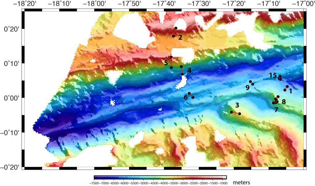
The north wall of the Romanche at the location of the first three dives is composed of a large thickness of basalts covered with a thick layer of sediments. Over practically the entire height of the wall explored during dives 2, 4 and 5, between 5700 m and about 1800 m, outcrops of basalts, which could correspond to massive flows, and basaltic breccia were observed. The wall has a steep slope (60-80°) from a depth of about 4800 m after a scree slope.
The last dive to explore the transform’s wall (15) took place further east of the first three at the ridge-transform intersection at the nodal basin. The Romanche nodal basin is exceptionally deep and reaches depths greater than 6500 m. The central part, the deepest, is filled with sediment. The north and south walls are covered with a thick sedimentary layer and no outcrop was observed. The rocks sampled in the scree are gabbros and peridotites. The presence of abundant gabbros on the north wall between 6000 and 5600 m is in agreement with the strong basaltic thickness observed further east. The crust exposed on this side of the Romanche seems to be much more magmatic than what was initially assumed.
Two dives (6 and 9) explored damage zone of the transform fault, in the southern part of the Romanche valley, quite wide at this point. The two dives crossed the fault track, visible in the surface bathymetry as a continuous line bordering an elongated topographic high, sometimes located in a depression between two elongated ridges. Both dives observed thin cracks in the sedimentary layer and alignments of rock fragments parallel to the direction of the transform. Both dive sites were covered with sediment, with some visible boulders, including polymictic breccia. The lithology of the samples obtained during the two dives is quite similar: plagioclase peridotites, some mylonitized, breccias and gabbros weakly deformed.
Four dives (1, 3, 7 and 8) explored two reliefs along the southern flank of the Romanche. The initial hypothesis was that these reliefs correspond to fragments of ancient “core complex”, isolated on the South American plate by a displacement of the axis of the ridge towards the East. These fragments are quite old and thus covered by a thick sedimentary layer, especially the one located further west. However, some outcrops were observed and mylonitized peridotites, showing deformation consistent with oceanic detachments, were sampled on all four dives. The structures observed on the eastern flank of the easternmost structure (dive 8) show a mylonitic foliation with orientation and dip consistent with the morphology. They correspond to the inner part of the “core complex” and their direct observation is exceptional, this part being very rarely exposed. The nature of the rocks (highly deformed peridotites) is compatible with the peridotite samples of the Romanche walls, especially the south wall (diving 15) and correspond to a context of low magmatic supply to the axis of the ridge. Dissymmetry between the north and south walls of this immense transform fault is therefore a major aspect of oceanic accretion in this portion of the Mid-Atlantic ridge.
By M. Maia